

AWAS-DT won
CES 2025 Innovation Award
Overview
Digital twin integrated control and authoring platform
AWAS-DT is equipped with STANS' Auto-i3D technology, easily creating 3D digital twin spaces from actual photos through photogrammetry technology.
Surveying that is difficult in reality can also be simulated on a digital twin, allowing you to check sunlight, view, distance, height, etc., and sensor data is displayed with various graphs so you can easily understand the status.
In addition, by linking with other solutions, we can provide integrated industrial processes such as 3D creation, image analysis, and education and training simulation, allowing industrial work to be performed efficiently.
Product Features
Product Features
Digital twin integrated control and authoring platform
- Easy 3D map creation using the DOI function
- Efficient authoring batch simulation
- Modular full-cycle authoring technology
- Supporting interfaces for scalability such as IEEE 2888 international standard
- Sensor data time series analysis virtual simulation
- Remote management through support for remote safety inspection, remote collaboration, video call and messaging functions
- Providing GIS information and location-based information


Function
Realistic digital twin with high-precision LOD
- By implementing a realistic digital twin with photo-based high-precision LOD (Level of Detail), users can immediately check the sunlight, view, distance, height, area, altitude, etc. of the actual space by simulating it in the digital twin space.
Automatic 3D modeling using only real photos by applying Auto-i3D technology
- Using STANS' unique Auto-i3D photogrammetry technology, you can quickly create a 3D model from real photos and create a 3D digital twin space without expert knowledge.
Implementation of ultra-precise visualization that can check even invisible, unstructured data
- It enables ultra-precise observation and remote management by visualizing unstructured objects or data such as water and smoke. Users can visualize data in various forms as needed and use it for real-time monitoring and decision-making.
Easy 3D map creation using STANS’ patented DOI function
- Using the DOI (Depth Of Information) structure, you can organize 3D models hierarchically to efficiently explore and manage them. This allows users to manage and navigate details such as flow paths and sensors through DOI settings.
Efficient authoring batch simulation considering optimized environment
- Optimize resources and operations through digital simulation. It supports realistic predictions and improvements, helping you operate efficiently and make decisions.
Modular full-cycle authoring technology through flexible linkage between AI engine and platform
- It provides a comprehensive digital transformation solution that can be used regardless of the type of industry, and modules for each solution can be combined or separated as needed to apply an integrated control authoring technology solution optimized for the field.
Benefit
Efficient operational management by building the site in 3D and intuitively visualizing complex data
Using AWAS-DT, field data such as sensor values and 3D spatial information can be customized and visualized by type to support efficient operation management.
User accessibility is easy because data can be understood from a spatial perspective regardless of skill level.
On-site management and maintenance
cost savings
Safety accident rate and energy consumption rate
Reducing Accidents and cost savings
Increased manufacturing/production process efficiency
80% increase in productivity
Field of application
Public · ITS. Energy · Eco-friendly · ESG

Manufacturing / Production
Real-time monitoring, control, and predictive management

Construction Engineering & Infrastructure
On-site safety monitoring, building/infrastructure design and simulation, management supervision

Energy · Eco-friendly · ESG
Operations monitoring, efficiency improvement, management, forecasting, analysis, simulation
Main Portfolio
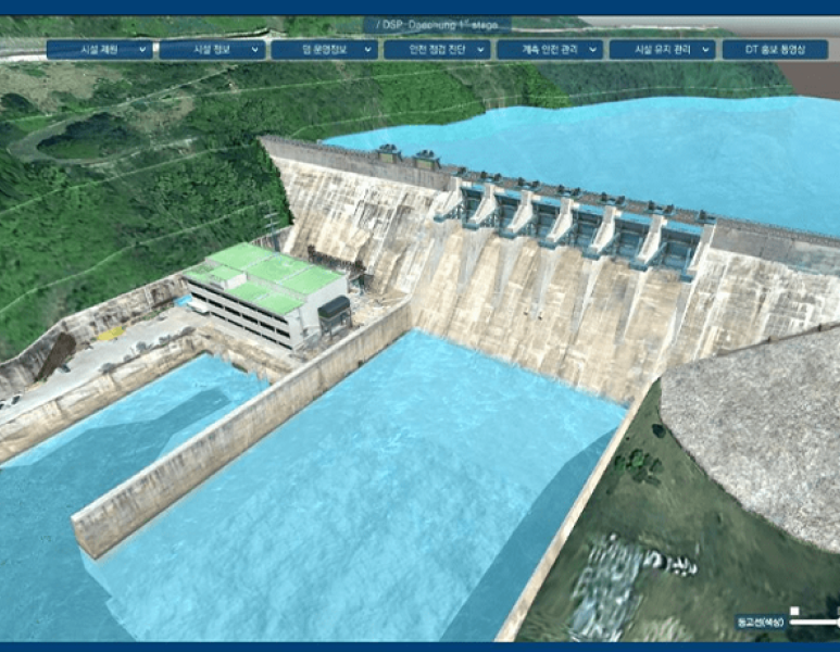
Korea Water Resources Corporation
Digital twin Daecheong Dam phase 1 pilot construction
Establishment of a platform that can collect, analyze, predict, and simulate information by configuring Daecheong Dam site as a digital twin model
functionMeasurement data monitoring, spatial information visualization, AI image analysis, remote collaboration, automatic report generation
effect Intuitive understanding of the field and efficient real-time remote management